Purchase History
| Date | Event | Price | Source | Agents |
|---|---|---|---|---|
| 11/01/2001 | Sold | $178,000 | Public records | |
| 09/18/2000 | Sold | $171,228 | Public records | |
| 02/06/1998 | Sold | $169,000 | Public records |
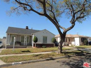
PURCHASE HISTORY 11643 St Andrews Pl, Los Angeles CA
Cost estimate history
| Year | Tax | Assessment | Market |
|---|---|---|---|
| 2014 | $3,168 | $214,498 | N/A |
Advertisement
Continue Reading Below
Market Activities
St Andrews Pl Fire Incident History
To date, we have no information about fire incidents in 2025
17 Dec 2019
Building fires
Property Use —
1 or 2 family dwelling
Area of Origin —
Bedroom - < 5 persons; included are jail or prison
First Ignition —
Cabinetry (including built-in)
Heat Source —
Heat from other open flame or smoking materials
08 Dec 2019
Trash or rubbish fire, contained
Property Use —
Residential street, road or residential driveway
Area of Origin —
Highway, parking lot, street: on or near
First Ignition —
Rubbish, trash, or waste
Heat Source —
Heat from undetermined smoking material
02 Dec 2019
Trash or rubbish fire, contained
Property Use —
1 or 2 family dwelling
Area of Origin —
Outside area, other
20 Nov 2019
Building fires
Property Use —
1 or 2 family dwelling
Area of Origin —
Outside area, other
First Ignition —
Exterior roof covering or finish
Heat Source —
Lightning
St Andrews Pl Incidents registered in FEMA
(Federal Emergency Management Agency)
To date, we have no information about incidents registered in FEMA in 2025
14 Aug 2015
Cooking fire, confined to container
Property Use —
1 or 2 family dwelling
25 Jun 2011
Gas leak (natural gas or LPG)
Property Use —
1 or 2 family dwelling
19 Oct 2008
Heat from short circuit (wiring), defective/worn
Property Use —
1 or 2 family dwelling
23 Mar 2007
Arcing, shorted electrical equipment
Property Use —
1 or 2 family dwelling
Properties Nearby
| Street Address |
|---|
461 St Andrews Pl, Los Angeles, CA 90004-3142 Single Family
|
920 St Andrews Pl, Los Angeles, CA 90038-3256 Multi-Family Home
|
1245 St Andrews Pl, Los Angeles, CA 90038-2211 Single Family
|