


Cost estimate history
| Year | Tax | Assessment | Market |
|---|---|---|---|
| 2013 | N/A | $18,200 | $36,400 |
Advertisement
Continue Reading Below
Market Activities
To date, we have no information about market activities in 2025
Jan 2023
Sold
Apr 2016
Recent Rent
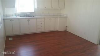
1825 22nd St
Price history :
- 3 beds
- 1 bath
Nice 3bd ,1bath corner lot . starts at $650 per mo. small pet may be considered 810-650-6901...
22nd St Fire Incident History
To date, we have no information about fire incidents in 2025
01 May 2018
Natural vegetation fire, other
Property Use —
1 or 2 family dwelling
Area of Origin —
Outside area, other
First Ignition —
Organic materials, other
Heat Source —
Cigarette
14 Nov 2013
Fire, other
Property Use —
Multifamily dwellings
Area of Origin —
Cooking area, kitchen
First Ignition —
Household utensils
Heat Source —
Radiated, conducted heat from operating equipment
09 Aug 2009
Building fires
Property Use —
Multifamily dwellings
Area of Origin —
Cooking area, kitchen
Heat Source —
Radiated, conducted heat from operating equipment
09 Jul 2008
Brush, or brush and grass mixture fire
Property Use —
Vacant lot
Area of Origin —
Outside area, other
First Ignition —
Light vegetation - not crop, including grass
22 St Incidents registered in FEMA
(Federal Emergency Management Agency)
To date, we have no information about incidents registered in FEMA in 2025
17 Aug 2014
Unauthorized burning
Property Use —
1 or 2 family dwelling
24 May 2014
Unauthorized burning
Property Use —
1 or 2 family dwelling
29 Apr 2014
Power line down
Property Use —
Pipeline, power line or other utility right of way
11 Apr 2014
Power line down
Property Use —
Vacant lot
Properties Nearby
| Street Address |
|---|
1812 22 St, Port Huron, MI 48060-6010 Single Family Residential
|
1813 22 St, Port Huron, MI 48060-6009 Unspecified
|
1815 22 St, Port Huron, MI 48060-6009 Single Family Residential |
1816 22 St, Port Huron, MI 48060-6010 Unspecified
|
1824 22 St, Port Huron, MI 48060-6010 Single Family Residential
|
1902 22 St, Port Huron, MI 48060-6012 Single Family Residential
|
1903 22 St, Port Huron, MI 48060-6011 Unspecified
|
1907 22 St, Port Huron, MI 48060-6011 Single Family Residential
|
1908 22 St, Port Huron, MI 48060-6012 Single Family Residential
|
1915 22 St, Port Huron, MI 48060-6011 Single Family Residential
|