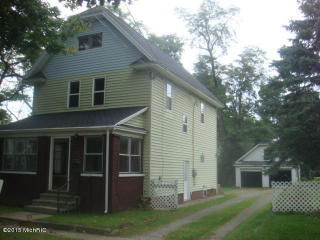
Cost estimate history
| Year | Tax | Assessment | Market |
|---|---|---|---|
| 2013 | N/A | $36,900 | N/A |
Advertisement
Continue Reading Below
Market Activities
Cherry St Fire Incident History
To date, we have no information about fire incidents in 2025
19 Jun 2016
Brush, or brush and grass mixture fire
Property Use —
Graded and cared-for plots of land
Area of Origin —
Wildland, woods
First Ignition —
Heavy vegetation - not crop, including trees
20 Jun 2015
Passenger vehicle fire
Property Use —
Vehicle parking area
Area of Origin —
Engine area, running gear, wheel area
Heat Source —
Radiated, conducted heat from operating equipment
541 Cherry St incidents registered in FEMA
(Federal Emergency Management Agency)
To date, we have no information about incidents registered in FEMA in 2025
21 Oct 2004
Unauthorized burning
Property Use —
1 or 2 family dwelling
Cherry St Incidents registered in FEMA
(Federal Emergency Management Agency)
To date, we have no information about incidents registered in FEMA in 2025
20 Nov 2015
Carbon monoxide incident
Property Use —
1 or 2 family dwelling
12 Nov 2015
Power line down
Property Use —
1 or 2 family dwelling
05 Jan 2015
Carbon monoxide incident
Property Use —
1 or 2 family dwelling
21 Jan 2013
Carbon monoxide incident
Property Use —
1 or 2 family dwelling
Properties Nearby
| Street Address |
|---|
527 Cherry St, Niles, MI 49120-3246 Single Family Residential
|
530 Cherry St, Niles, MI 49120-3247 Single Family Residential
|
531 Cherry St, Niles, MI 49120-3246 Single Family Residential
|
535 Cherry St, Niles, MI 49120-3246 Single Family Residential
|
536 Cherry St, Niles, MI 49120-3247 Single Family Residential
|
542 Cherry St, Niles, MI 49120-3247 Single Family Residential
|
548 Cherry St, Niles, MI 49120-3247 Single Family Residential
|
556 Cherry St, Niles, MI 49120-3247 Single Family Residential
|
557 Cherry St, Niles, MI 49120-3246 Single Family Residential
|
560 Cherry St, Niles, MI 49120-3247 Single Family Residential
|

