Whiteville Rd, Shepherd MI

59 properties and 244 residents found on Whiteville Rd, Shepherd, MI. Find out more information with Homemetry Address Directory.

Advertisement
Continue Reading Below

Residents

Advertisement
Continue Reading Below
  • Lot: 2.66 acres

Facts

Lot size: 2.66 acres

  • Lot: 9.77 acres

Facts

Lot size: 9.77 acres

  • Lot: 9.77 acres

Facts

Lot size: 9.77 acres

Advertisement
Continue Reading Below
  • Lot: 1.47 acres

Facts

Lot size: 1.47 acres

  • Lot: 0.98 acres

Facts

Lot size: 0.98 acres

  • Lot: 1.71 acres

Facts

Lot size: 1.71 acres

  • Lot: 1.95 acres

Facts

Lot size: 1.95 acres

Advertisement
Continue Reading Below
  • 5 beds
  • 3 baths
  • Lot: 6.84 acres

Facts

Lot size: 6.84 acres
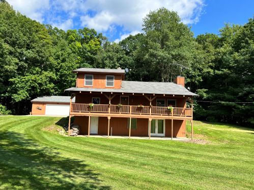
7291 Whiteville Rd, Shepherd, MI 48883-8513
For Sale $249,000
  • Lot: 0.98 acres

Facts

Lot size: 0.98 acres

  • Lot: 18.11 acres

Facts

Lot size: 18.11 acres

  • Lot: 1.11 acres

Facts

Lot size: 1.11 acres

Advertisement
Continue Reading Below
  • Lot: 1.17 acres

Facts

Lot size: 1.17 acres

  • Lot: 12.7 acres

Facts

Lot size: 12.7 acres

  • Lot: 9.77 acres

Facts

Lot size: 9.77 acres

Advertisement
Continue Reading Below
  • Lot: 1.95 acres

Facts

Lot size: 1.95 acres

  • Lot: 9.77 acres

Facts

Lot size: 9.77 acres

  • Lot: 2.93 acres

Facts

Lot size: 2.93 acres

Advertisement
Continue Reading Below
  • Lot: 9.77 acres

Facts

Lot size: 9.77 acres

  • Lot: 1.76 acres

Facts

Lot size: 1.76 acres

Advertisement
Continue Reading Below
  • Lot: 2.25 acres

Facts

Lot size: 2.25 acres

  • Lot: 1.09 acres

Facts

Lot size: 1.09 acres

Advertisement
Continue Reading Below
  • Lot: 13.68 acres

Facts

Lot size: 13.68 acres

  • Lot: 0.98 acres

Facts

Lot size: 0.98 acres

  • Lot: 6.6 acres

Facts

Lot size: 6.6 acres

  • Lot: 9.77 acres

Facts

Lot size: 9.77 acres

Advertisement
Continue Reading Below
  • 3 beds
  • 1 bath
  • Lot: 4.89 acres

Facts

Lot size: 4.89 acres

Advertisement
Continue Reading Below
  • Lot: 8.79 acres

Facts

Lot size: 8.79 acres

  • Lot: 20.03 acres

Facts

Lot size: 20.03 acres

  • Lot: 9.77 acres

Facts

Lot size: 9.77 acres

Advertisement
Continue Reading Below
  • Lot: 9.77 acres

Facts

Lot size: 9.77 acres

  • Lot: 9.77 acres

Facts

Lot size: 9.77 acres

Advertisement
Continue Reading Below
  • Lot: 0.98 acres

Facts

Lot size: 0.98 acres

  • Lot: 4.89 acres

Facts

Lot size: 4.89 acres

  • Lot: 2.93 acres

Facts

Lot size: 2.93 acres

  • Lot: 6.69 acres

Facts

Lot size: 6.69 acres

Advertisement
Continue Reading Below
  • Lot: 0.98 acres

Facts

Lot size: 0.98 acres

  • Lot: 1.95 acres

Facts

Lot size: 1.95 acres

Advertisement
Continue Reading Below
  • Lot: 0.98 acres

Facts

Lot size: 0.98 acres

  • Lot: 2.01 acres

Facts

Lot size: 2.01 acres

  • Lot: 2.27 acres

Facts

Lot size: 2.27 acres

Market Activities

To date, we have no information about market activities in 2025
Sep 2023 Listed for sale
7291 Whiteville Rd
Price history :
  • Single Family
  • 2,736 sqft
  • 5 beds
  • 3 baths
Mar 2016 Sold
8364 Whiteville Rd
  • Single-Family Home
  • 1,040 sqft
  • 5.0 acres
  • 3 beds
  • 1 bath

View more

Fire Incident History

To date, we have no information about fire incidents in 2025
06 Apr 2014 Grass fire
Property Use —
Open land or field
Area of Origin —
Incinerator area
First Ignition —
Light vegetation - not crop, including grass
Heat Source —
Flying brand, ember, spark
07 Sep 2011 Grass fire
Property Use —
Pipeline, power line or other utility right of way
Area of Origin —
Highway, parking lot, street: on or near
First Ignition —
Light vegetation - not crop, including grass
25 Mar 2009 Grass fire
Property Use —
Open land or field
Area of Origin —
Incinerator area
First Ignition —
Rubbish, trash, or waste
Heat Source —
Flying brand, ember, spark
15 Jan 2008 Building fires
Property Use —
1 or 2 family dwelling
Area of Origin —
Wall surface: exterior
First Ignition —
Structural member or framing
Heat Source —
Radiated heat from another fire

View more

Incidents registered in Federal Emergency Management Agency

To date, we have no information about incidents registered in FEMA in 2025
01 Nov 2011 Outside rubbish, trash or waste fire
Property Use —
1 or 2 family dwelling
25 May 2008 Outside rubbish, trash or waste fire
Property Use —
1 or 2 family dwelling
11 Nov 2006 Power line down
Property Use —
Pipeline, power line or other utility right of way
23 Feb 2006 Power line down
Property Use —
Pipeline, power line or other utility right of way

View more

Advertisement
Continue Reading Below

Comparison graphs

House prices on 5999-9957 Whiteville Rd, Shepherd MI

70217218727572777300735374807595773977907823826582809000926193639400947894959903House Number$0$30k$60k$90k$120k$150k$180k$210k$240k$270k$300k$330k$360k$390kPrices

Lot size and building area (in sqft) on 5999-9957 Whiteville Rd, Shepherd MI

7021716672187260727572767277729173007340735373607480759475957700773977707790781278238130826582788280836490009100926193519363936894009404947894879495983799039957House Number0100,000200,000300,000400,000500,000600,000700,000800,000900,000Area (in sqft)Lot size

Where is Whiteville Rd, Shepherd MI located on map?

Advertisement
Advertisement