Pine St, Marshfield MO street index
| Block | Buildings | Properties | Businesses | Residents |
|---|---|---|---|---|
| 500-1099 | 502-1019 | 48 | 14 | 231 |
| 1100-1740 | 1100-1740 | 33 | 3 | 127 |
Residents
Advertisement
Continue Reading Below
Residence for Single Family
- Lot: 0.92 acres
- Built in 1968
Facts
Lot size: 0.92 acres
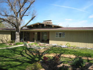
Sold $219,900
Advertisement
Continue Reading Below
Residence for Single Family
- Lot: 1.12 acres
- Built in 1980
Facts
Lot size: 1.12 acres

Advertisement
Continue Reading Below
Advertisement
Continue Reading Below
Advertisement
Continue Reading Below
Advertisement
Continue Reading Below
Advertisement
Continue Reading Below
Market Activities
To date, we have no information about market activities in 2025
Sep 2016
Sold
Jul 2016
Sold
May 2016
Sold
Apr 2016
Sold
Mar 2016
Sold
Jan 2016
Sold
Fire Incident History
To date, we have no information about fire incidents in 2025
22 Jun 2015
Special outside fire, other
Property Use —
1 or 2 family dwelling
Area of Origin —
Open area - outside; included are farmland, field
First Ignition —
Light vegetation - not crop, including grass
24 Jan 2014
Grass fire
Property Use —
Vacant lot
24 Nov 2013
Building fires
Property Use —
1 or 2 family dwelling
Area of Origin —
Substructure area or space, crawl space
Heat Source —
Heat from other open flame or smoking materials
07 Dec 2008
Grass fire
Property Use —
Vacant lot
Area of Origin —
Open area - outside; included are farmland, field
Incidents registered in Federal Emergency Management Agency
To date, we have no information about incidents registered in FEMA in 2025
26 Mar 2012
Outside rubbish, trash or waste fire
Property Use —
Vacant lot
09 Aug 2004
Outside rubbish, trash or waste fire
Property Use —
1 or 2 family dwelling
08 May 2004
Building fires
25 Jan 2004
Electrical wiring/equipment problem, other
Property Use —
Pipeline, power line or other utility right of way