Pittston Ave, Scranton PA street index
Residents
Advertisement
Continue Reading Below
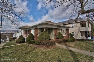
- 3 beds
- 2 baths
- 2,800 sqft
Facts
Lot size: 3,600 sqft
Parking: Carport, Garage - Attached, Garage - Detached

Advertisement
Continue Reading Below
Advertisement
Continue Reading Below
- 4 beds
- 2 baths
- 1,034 sqft
Facts
Lot size: 6,400 sqft
Advertisement
Continue Reading Below
- Lot: 2,800 sqft
Facts
Lot size: 2,800 sqft
Sold $95,000
Advertisement
Continue Reading Below
Advertisement
Continue Reading Below
Advertisement
Continue Reading Below
Advertisement
Continue Reading Below
Advertisement
Continue Reading Below
Market Activities
To date, we have no information about market activities in 2025
Aug 2016
Sold
Mar 2016
Sold
Mar 2016
Sold
Fire Incident History
To date, we have no information about fire incidents in 2025
08 Jun 2019
Outside storage fire
Property Use —
Residential street, road or residential driveway
02 May 2018
Building fires
Property Use —
1 or 2 family dwelling
Area of Origin —
Outside area, other
14 Mar 2017
Passenger vehicle fire
Property Use —
Street or road in commercial area
Area of Origin —
Engine area, running gear, wheel area
07 Oct 2016
Passenger vehicle fire
Property Use —
Residential street, road or residential driveway
Area of Origin —
Highway, parking lot, street: on or near
First Ignition —
Liquids, piping, filters, other
Heat Source —
Hot or smoldering object, other
Incidents registered in Federal Emergency Management Agency
To date, we have no information about incidents registered in FEMA in 2025
01 Nov 2015
Arcing, shorted electrical equipment
Property Use —
Residential street, road or residential driveway
11 Jun 2015
Cooking fire, confined to container
Property Use —
1 or 2 family dwelling
30 Apr 2015
Cooking fire, confined to container
Property Use —
Business office
16 Apr 2015
Cooking fire, confined to container
Property Use —
Multifamily dwellings
Advertisement
Continue Reading Below