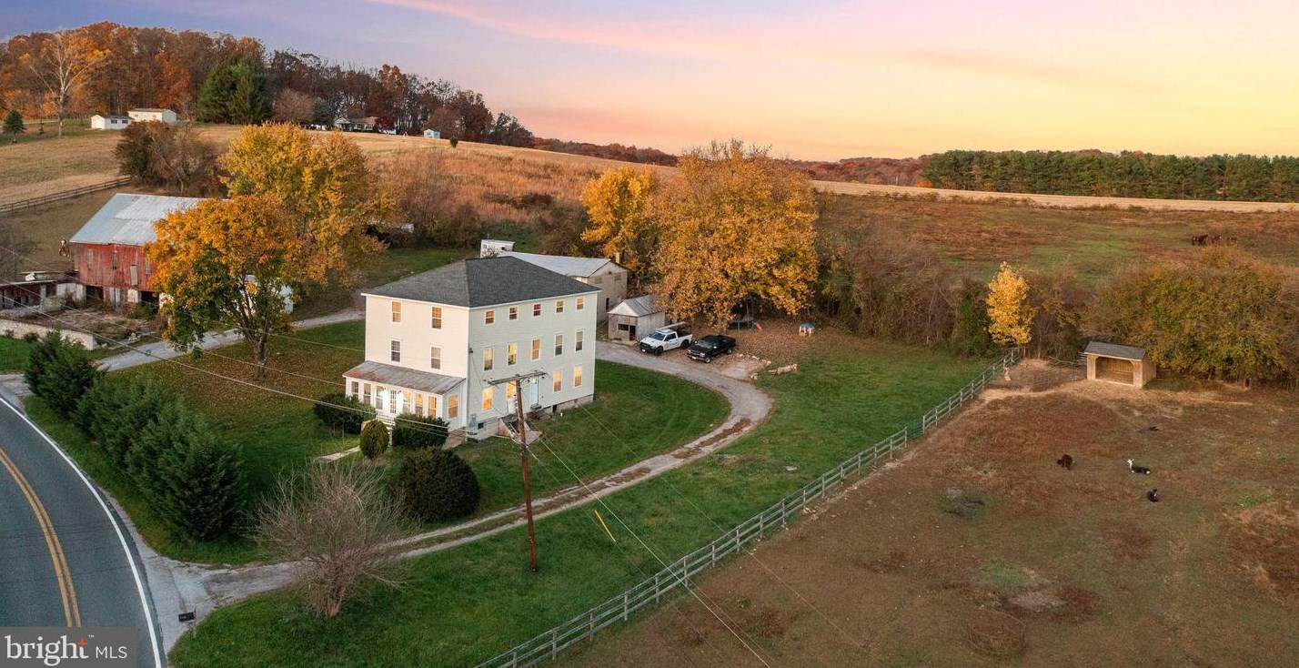
1843 Albert Rill Rd Hampstead, MD 21074 / 1024

Residence for Single Family

(UPDATED: 09/09/2025)
  • 4 Beds
  • 2 Baths
  • 14.68 acres
Sold Feb 2023
$660,000
Property Report

Information about property on 1843 Albert Rill Rd, Hampstead MD, 21074-1024. Find out owner contacts, building history, price, neighborhood at Homemetry Address Directory.

Property Details

Built in 1900, the property has an aluminum and vinyl facade, metal roof and basement on 14,68 acres lot.

Facts

  • Built in 1900
  • Lot size 14,68 acres
  • Bathrooms 2
  • Stories 2 story with basement
  • Basement Basement (not specified)
  • Heating & Cooling
  • Heat type Forced air unit
  • Exterior Home Features
  • Exterior walls Siding (Alum/Vinyl)
  • Roof type Metal
Advertisement
Continue Reading Below

Misc

  • Units 1

Householders and Tenants for 1843 Albert Rill Rd, Hampstead MD

Purchase History

DateEventPriceSourceAgents
06/27/2014 Sold $377,472 Public records
04/25/2008 Sold $425,000 Public records

Cost estimate history

YearTaxAssessmentMarket
2014 N/A $142,000 $142,000
Advertisement
Continue Reading Below

Where is 1843 Albert Rill Rd, Hampstead MD located on map?

Market Activities

To date, we have no information about market activities in 2025
Feb 2023 Sold
1843 Albert Rill Rd
Price history :
  • Single Family
  • 6,188 sqft
  • 4 beds
  • 4 baths
Jan 2023 Sold
1843 Albert Rill Rd
Price history :
  • Single Family
  • 6,188 sqft
  • 4 beds
  • 4 baths
Jun 2015 Sold
1843 Albert Rill Rd
Price history :
  • Single-Family Home
  • 1,282 sqft
  • 15.04 acres
  • 2 baths

View more

Albert Rill Rd Fire Incident History

To date, we have no information about fire incidents in 2025
24 Nov 2017 Brush, or brush and grass mixture fire
Property Use —
Open land or field
Area of Origin —
Open area - outside; included are farmland, field
First Ignition —
Light vegetation - not crop, including grass

Albert Rill Rd Incidents registered in FEMA
(Federal Emergency Management Agency)

To date, we have no information about incidents registered in FEMA in 2025
24 May 2007 Aircraft standby
Property Use —
Vehicle parking area
09 May 2007 Power line down
19 Feb 2007 Building or structure weakened or collapsed
Property Use —
Outbuilding or shed
06 Jan 2006 Chimney or flue fire, confined to chimney or flue

View more

Properties Nearby

Street Address
1809 Albert Rill Rd, Hampstead, MD 21074-1024
Single Family Residential
  • 1 bath
  • Lot: 2.05 acres
  • Built in 1977
1811 Albert Rill Rd, Hampstead, MD 21074-1024
Multi-Family Home
  • Lot: 2.26 acres
  • Built in 1977
1844 Albert Rill Rd, Hampstead, MD 21074-1025
Single Family Residential
  • 1 bath
  • Lot: 3.97 acres
  • Built in 1958
1856 Albert Rill Rd, Hampstead, MD 21074-1025
Single Family Residential
  • 1 bath
  • Lot: 1.93 acres
  • Built in 1972
 

FAQ about the house at 1843 Albert Rill Rd, Hampstead, MD

Advertisement

NOTICE: You may not use Homemetry or the information it provides to make decisions about employment, credit, housing or any other purpose that would require Fair Credit Reporting Act (FCRA) compliance. Homemetry is not a Consumer Reporting Agency (CRA) as defined by the FCRA and does not provide consumer reports.