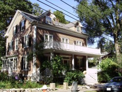
Cost estimate history
| Year | Assessment | ||
|---|---|---|---|
| 2016 | $924,700 | ||
| 2015 | $864,200 | ||
| 2014 | $830,000 | ||
| 2013 | $830,000 | ||
| 2012 | $830,000 | ||
| 2011 | $826,600 | ||
| 2010 | $843,500 | ||
| 2009 | $860,700 | ||
| 2008 | $860,700 | ||
| 2007 | $914,300 | ||
| 2006 | $887,700 | ||
| 2005 | $845,400 | ||
| 2004 | $782,100 | ||
| 2003 | $698,300 | ||
| 2002 | $698,300 | ||
| 2001 | $583,400 | ||
| 2000 | $532,800 | ||
| 1999 | $528,900 | ||
| 1998 | $422,100 | ||
| 1997 | $407,800 | ||
| 1996 | $388,400 | ||
| 1995 | $357,100 | ||
| 1994 | $357,100 | ||
| 1993 | $357,100 | ||
| 1992 | $355,000 |
Advertisement
Continue Reading Below
Market Activities
Hawthorne Ave Incidents registered in FEMA
(Federal Emergency Management Agency)
To date, we have no information about incidents registered in FEMA in 2025
23 Jul 2014
Gas leak (natural gas or LPG)
Property Use —
1 or 2 family dwelling
28 Jun 2010
Arcing, shorted electrical equipment
Property Use —
Residential street, road or residential driveway
13 Mar 2003
Gasoline or other flammable liquid spill
Property Use —
Parking garage, (detached residential garage)
01 Mar 2003
EMS call, excluding vehicle accident with injury
Property Use —
1 or 2 family dwelling
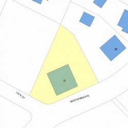
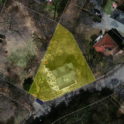
Properties Nearby
| Street Address |
|---|
6 Hawthorne Ave, Newton, MA 02466-2806 Single Family
|
19 Hawthorne Ave, Newton, MA 02466-2805 Two Family
|
24 Hawthorne Ave, Newton, MA 02466-2806 Single Family
|
25 Hawthorne Ave, Newton, MA 02466-2805 Single Family
|
29 Hawthorne Ave, Newton, MA 02466-2805 Single Family
|
30 Hawthorne Ave, Newton, MA 02466-2806 Single Family
|