43 Fisher Ave, Newton MA  02461-1142 exterior

43 Fisher Ave Newton, MA 02461 / 1142

Residence for Single Family

(UPDATED: 07/05/2025)
  • 4 Beds
  • 3 Baths
  • 3.938 square feet
Property Report

Information about property on 43 Fisher Ave, Newton MA, 02461-1142. Find out owner contacts, building history, price, neighborhood at Homemetry Address Directory.

Property Details

At 43 Fisher Avenue, Newton, MA based a property, which was built in 1899.

Facts

  • Built in 1899
  • Property use Single Family
  • Lot size 7,430 sqft
  • Effective area 3,294 sqft
  • Gross building area 3,938 sqft
  • Building type Residential
  • Rooms 8
  • Bedrooms 4
  • Bathrooms 3
  • Stories 2,5
  • Exterior condition Average
  • Trim None
  • Foundation type Brick/Fldstone
  • Roof material Asphalt Shingl
  • Fuel type Gas
  • Air conditioning Central
  • Frontage 97 feet
  • Basement area 962 sqft
  • Finished basement area 322 sqft
  • Shed area 136 sqft
  • Porch area 80 sqft
  • Deck area 260 sqft
  • Heating & Cooling
  • Heat type Forced Air-Duc
  • Exterior Home Features
  • Exterior walls Wood Shingle
  • Roof type Gable
Advertisement
Continue Reading Below

Features

  • Kitchen quality: Above Average
  • Interior condition: Good

Householders and Tenants for 43 Fisher Ave, Newton MA

Businesses

Organization Phone Number Additional Info
KENDRICK REALTY TRUST
Type of Business:
Voluntary Associations and Trusts
43 Fisher Ave, Newton MA  02461-1142 plot plan 43 Fisher Ave, Newton MA  02461-1142 floor plan 43 Fisher Ave, Newton MA  02461-1142 aerial view

Purchase History

DateEventPriceSourceAgents
08/11/2010 Sold $930,000 Public records
06/06/2006 Sold $926,000 Public records
08/01/2003 Sold $800,000 Public records
12/29/2000 Sold $625,000 Public records

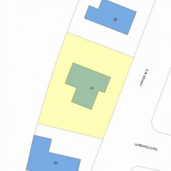
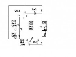
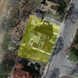
PURCHASE HISTORY 43 Fisher Ave, Newton MA

12/29/200006/06/2006Date$0$100k$200k$300k$400k$500k$600k$700k$800k$900k$1.0MPrices

Cost estimate history

YearAssessment
2016 $956,500
2015 $893,900
2014 $876,300
2013 $876,300
2012 $876,300
2011 $741,300
2010 $756,400
2009 $771,800
2008 $775,200
2007 $737,200
2006$715,700
2005$681,600
2004$635,400
2003$567,300
2002$567,300
2001$486,300
2000$444,100
1999$404,100
1998$383,800
1997$352,100
1996$335,300
1995$302,600
1994$285,500
1993$285,500
1992$282,700
Advertisement
Continue Reading Below

Where is 43 Fisher Ave, Newton MA located on map?

Fisher Ave Incidents registered in FEMA
(Federal Emergency Management Agency)

To date, we have no information about incidents registered in FEMA in 2025
29 Oct 2011 Power line down
Property Use —
1 or 2 family dwelling

Properties Nearby

Street Address
3 Fisher Ave, Newton, MA 02461-1145
Single Family
  • 2 beds
  • 1 bath
  • 2,635 sqft
  • Built in 1910
31 Fisher Ave, Newton, MA 02461-1142
Single Family
  • 4 beds
  • 2.5 baths
  • 2,882 sqft
  • Built in 1897
32 Fisher Ave, Newton, MA 02461-1117
Single Family
  • 4 beds
  • 1.5 baths
  • 4,934 sqft
  • Built in 1896
37 Fisher Ave, Newton, MA 02461-1142
Single Family
  • 3 beds
  • 1.5 baths
  • 2,548 sqft
  • Built in 1898
42 Fisher Ave, Newton, MA 02461-1117
Two Family
  • 3 beds
  • 3 baths
  • 2,796 sqft
  • Built in 1931
 

FAQ about the house at 43 Fisher Ave, Newton, MA

Advertisement

NOTICE: You may not use Homemetry or the information it provides to make decisions about employment, credit, housing or any other purpose that would require Fair Credit Reporting Act (FCRA) compliance. Homemetry is not a Consumer Reporting Agency (CRA) as defined by the FCRA and does not provide consumer reports.