Cost estimate history
| Year | Tax | Assessment | Market |
|---|---|---|---|
| 2013 | $6,927 | $295,000 | N/A |
Advertisement
Continue Reading Below
Market Activities
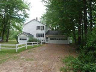
Kimball Dr Fire Incident History
To date, we have no information about fire incidents in 2025
07 Jun 2017
Building fires
Property Use —
1 or 2 family dwelling
30 Aug 2005
Passenger vehicle fire
Property Use —
Vehicle parking area
Area of Origin —
Exterior, exposed surface
69 Kimball Dr incidents registered in FEMA
(Federal Emergency Management Agency)
To date, we have no information about incidents registered in FEMA in 2025
26 Nov 2014
Arcing, shorted electrical equipment
Property Use —
Residential street, road or residential driveway
28 Nov 2009
Electrical wiring/equipment problem, other
Property Use —
Residential street, road or residential driveway
Kimball Dr Incidents registered in FEMA
(Federal Emergency Management Agency)
To date, we have no information about incidents registered in FEMA in 2025
26 Nov 2014
Arcing, shorted electrical equipment
Property Use —
Residential street, road or residential driveway
10 Oct 2013
Authorized controlled burning
Property Use —
General retail, other
21 Aug 2013
Brush, or brush and grass mixture fire
Property Use —
General retail, other
07 Feb 2013
Carbon monoxide incident
Property Use —
1 or 2 family dwelling
Properties Nearby
| Street Address |
|---|
11 Kimball Dr, Manchester, NH 03106-2603 High Rise |
49 Kimball Dr, Manchester, NH 03106-2617 Lot/Land
|
52 Kimball Dr, Manchester, NH 03106-2618 Single Family
|
69-A Kimball Dr, Manchester, NH 03106
|
73 Kimball Dr, Manchester, NH 03106-2617 Single Family Residential
|
87 Kimball Dr, Manchester, NH 03106-2617 Single Family Residential
|