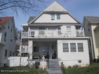

Purchase History
| Date | Event | Price | Source | Agents |
|---|---|---|---|---|
| 05/16/2014 | Sold | $25,000 | Public records |
Cost estimate history
| Year | Tax | Assessment | Market |
|---|---|---|---|
| 2014 | $1,742 | $9,400 | $9,400 |
Advertisement
Continue Reading Below
Market Activities
Irving Ave Fire Incident History
To date, we have no information about fire incidents in 2025
12 Oct 2016
Building fires
Property Use —
1 or 2 family dwelling
Area of Origin —
Closet
First Ignition —
Wearing apparel not on a person
Heat Source —
Heat source: other
02 Oct 2016
Passenger vehicle fire
03 Dec 2015
Building fires
Property Use —
1 or 2 family dwelling
Area of Origin —
Egress/exit, other
First Ignition —
Structural component or finish, other
25 Apr 2015
Building fires
Property Use —
Manufacturing, processing
Irving Ave Incidents registered in FEMA
(Federal Emergency Management Agency)
To date, we have no information about incidents registered in FEMA in 2025
05 Dec 2015
Carbon monoxide incident
Property Use —
1 or 2 family dwelling
16 Nov 2015
Gas leak (natural gas or LPG)
Property Use —
1 or 2 family dwelling
29 Aug 2015
Cooking fire, confined to container
Property Use —
Residential board and care
25 May 2015
Cooking fire, confined to container
Property Use —
Residential board and care
Properties Nearby
| Street Address |
|---|
704 Irving Ave, Scranton, PA 18505-1922 Single Family Residential
|
706 Irving Ave, Scranton, PA 18505-1922 Single Family Residential
|
708 Irving Ave, Scranton, PA 18505-1922 Unspecified
|
712 Irving Ave, Scranton, PA 18505-3556 Single Family Residential
|
713 Irving Ave, Scranton, PA 18505-1921 Single Family Residential
|
720 Irving Ave, Scranton, PA 18505-3555 Single Family Residential
|
721 Irving Ave, Scranton, PA 18505-3543 Multi-Family Home
|
723 Irving Ave, Scranton, PA 18505-3544 Single Family Residential
|
724 Irving Ave, Scranton, PA 18505-1922 Multi-Family Home
|
725 Irving Ave, Scranton, PA 18505-1921 Single Family Residential
|