Purchase History
| Date | Event | Price | Source | Agents |
|---|---|---|---|---|
| 11/15/2014 | Price Change -$9K (-8.3%) | $99,900 | Berrien Property via Point2 | |
| 10/11/2014 | Price Change | $109,000 | Berrien Property via Point2 | |
| 08/30/2013 | Sold | $74,000 | Public records |
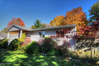
PURCHASE HISTORY 969 14th St, Niles MI
Cost estimate history
| Year | Tax | Assessment | Market |
|---|---|---|---|
| 2013 | N/A | $24,000 | N/A |
Advertisement
Continue Reading Below
Market Activities
14th St Fire Incident History
To date, we have no information about fire incidents in 2025
01 Feb 2018
Building fires
Property Use —
Manufacturing, processing
Area of Origin —
Machinery room or area; elevator machinery room
Heat Source —
Spark, ember or flame from operating equipment
09 Apr 2017
Grass fire
Property Use —
1 or 2 family dwelling
01 Feb 2011
Building fires
Property Use —
1 or 2 family dwelling
Area of Origin —
Wall assembly
First Ignition —
Structural member or framing
Heat Source —
Arcing
23 Oct 2010
Brush, or brush and grass mixture fire
Property Use —
1 or 2 family dwelling
Area of Origin —
Highway, parking lot, street: on or near
First Ignition —
Light vegetation - not crop, including grass
969 14 St incidents registered in FEMA
(Federal Emergency Management Agency)
To date, we have no information about incidents registered in FEMA in 2025
09 Aug 2000
Authorized controlled burning
Property Use —
1 or 2 family dwelling
14 St Incidents registered in FEMA
(Federal Emergency Management Agency)
To date, we have no information about incidents registered in FEMA in 2025
27 Feb 2015
Carbon monoxide incident
Property Use —
1 or 2 family dwelling
04 Oct 2013
Authorized controlled burning
Property Use —
1 or 2 family dwelling
08 Aug 2013
Chimney or flue fire, confined to chimney or flue
Property Use —
Manufacturing, processing
08 Aug 2013
Building fires
Property Use —
Manufacturing, processing
Properties Nearby
| Street Address |
|---|
937 14 St, Niles, MI 49120-3847 Single Family Residential |
948 14 St, Niles, MI 49120-3848 Single Family Residential
|
958 14 St, Niles, MI 49120-3848 Single Family Residential
|
961 14 St, Niles, MI 49120-3847 Single Family Residential
|
965 14 St, Niles, MI 49120-3847 Single Family Residential
|
972 14 St, Niles, MI 49120-3848 Single Family Residential
|
974 14 St, Niles, MI 49120-3848 Single Family Residential
|
975 14 St, Niles, MI 49120-3847 Single Family Residential
|
980 14 St, Niles, MI 49120-3848 Single Family Residential
|
985 14 St, Niles, MI 49120-3847 Single Family Residential
|